Guests who walk the Hachinohe section of the Michinoku Coastal Trail all the way to Okuki come back and ask, almost without exception, the same thing: what is after that?
After that is Hashikami. It is the town immediately south of us, still on the JR Hachinohe Line, and the trail runs about 33km through it — more than double the Hachinohe section. It is also the only part of this 1,000km-plus trail that climbs a mountain: Mt. Hashikami, 739.6m.
Which means that if you set out feeling like you are simply continuing yesterday's walk, several things will be missing. This article is about sorting those out in advance.
What lies beyond the Hachinohe section
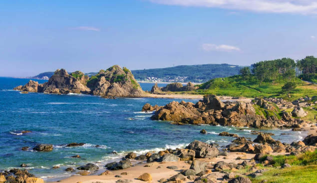
The JR Hachinohe Line keeps hugging the sea after Okuki, the southern end of the Hachinohe section. Kanahama, then Oja, then Hashikami. The town boundary changes nothing about how close the rails sit to the water.
The route the town of Hashikami promotes begins around Oja Station. It leaves the coast for a shopping street that still looks like Showa-era Japan, climbs into the hills, goes up and over Mt. Hashikami, drops back to the sea, and finishes at Kominato Coast on the prefectural border. The town describes it as a road through satochi, satoyama and satoumi — settled land, wooded hills, and working coast. That is a different animal from the single coastal line of the Hachinohe section. The full route is laid out on the town's Michinoku Coastal Trail page (Japanese).
Same trail name, completely different character
When I recommend the Hachinohe section, I always describe it the same way: flat, 12km, and you can quit anywhere. The virtue of that section is that it lets you fail.
Hashikami breaks all three of those. About 33km, one climb of nearly 740m, and long stretches where the trail leaves the railway behind. Walked end to end, the standard time comes out at over eleven hours — this is not a day trip. Think of it as a section that experienced long-distance walkers take several days over.
None of which means it is off-limits if you only have a day. Cut it the right way and a day here is excellent. What I actually hand guests is not the 33km, but a choice of three: the first leaves the official route to stay by the sea, while the second and third are built around Mt. Hashikami, which is on it.
Three ways to cut it into one day
1. The sea only (Oja to Kominato Coast)
One thing to be clear about first: this is not the official Michinoku Coastal Trail route. As described above, the waymarked course leaves the sea after Oja, climbs into the hills and over Mt. Hashikami, and only returns to the coast near Kominato. So if you walk the shoreline from Oja to Kominato you will not pass any trail waymarks. There are none to find, so go knowing that.
With that said, this is what I suggest to people who want the sea without the mountain. Get off at Oja or Hashikami Station, head south along the Hashikami coast, and finish at Kominato Coast on the border. You come away understanding, in your legs, that the same reef-and-lawn coastline runs all the way to the prefectural line. There is no single continuous footpath, though — you are linking up roads and paths along the shore, and the distance depends on the line you draw, so plan your route on a map before you set out.
This is what I suggest for anyone who is not a regular walker, who has half a day rather than a full one, or whose legs are still full of yesterday's 12km. You are returning to a station on the same line, so planning your escape works exactly as it did in Hachinohe.
2. The mountain only (Obirakitai to the summit)
This is the shortest possible way to end a day having climbed the trail's only mountain. A road runs up Mt. Hashikami as far as Obirakitai at the eighth station, and from there a gentle walking path continues to the top — around thirty minutes, per the town. It is closer to a ridge stroll than a climb.
If you would rather earn the summit, there is a full route from Forestpia Hashikami: 4.79km one way, about two hours. Trailheads and details are on the town's Mt. Hashikami page (Japanese).
The mountain is also called Gagyuzan, "reclining ox", after the shape of its slopes. It was designated part of Sanriku Fukko National Park in May 2013, together with the Hashikami coast. Obirakitai at the eighth station is a natural azalea field; from late May to early June it is busy with people who have come only for the flowers.
3. Up from Terashita Kannon
Mt. Hashikami has several trailheads: one in the centre of town, one in the Tashiro district to the west, and one at Terashita, where the Kannon hall stands. Starting from Terashita is the most characteristically Hashikami of the three, because you climb out of a village place of worship and into the hills. Walk it and the town's phrase about a road connecting mountain and sea stops being a slogan.
If the climb sounds like too much, you can also walk the temple grounds and simply not go up. The grounds are a destination in their own right.
Terashita Kannon and an 800-year-old ginkgo
Terashita Kannon is the one place in the Hashikami section I most want guests to see. The hall of Shioyama Shrine here is the former Kannon hall, built in 1626 and still standing in use.
Beside it is a ginkgo estimated at 800 years old — 10.1m around the trunk and 23m tall. Written as numbers it is just a big tree; in person it is the girth you notice first. The surrounding grounds also hold three more of the town's registered ancient trees: the Terashita Kannon wisteria, the Terashita metasequoia, and the Ryujin pine.
There is a marked walking circuit of about sixty minutes taking in the grounds and nearby sites including the old lantern hall. It is worth the trip on a day when you are not walking the trail at all, and it is a different kind of afternoon from the places on our area guide.
Kominato Coast, where Aomori sees the sun first
Kominato Coast, the southern end of the Hashikami section, is the border between Aomori and Iwate. Border markers stand on both the land and the sea side, the land one placed in 1951. A boundary stone standing out in the water is the sort of detail that makes a place easy to remember.
An 11m lighthouse stands on the shore with a gentle lawn spreading below it. Grass running down to the sea puts it in the same family as Tanesashi Coast, but with far fewer people. It is part of Sanriku Fukko National Park, and the shoreline alternates between lawn and rock as you walk it.
This is also the south-easternmost point in the prefecture, and said to be where the sun rises earliest in Aomori. Getting here for sunrise runs straight into the transport problem below, but it is a target worth knowing about.
Transport: the stations are the easy part
The real obstacle in Hashikami is not the mountain, it is getting around. The Hachinohe section had the Umineko sightseeing bus stopping at the highlights. Hashikami has no equivalent.
- JR Hachinohe Line — Okuki, Kanahama, Oja, Hashikami. Roughly one train every one to two hours during the day. Arrive at a station on city instincts and you will wait an hour
- Hashikami community bus — it does run, but check routes and times on the town's own site. It is local transport, not a tourist service, and some hours simply do not work
- Taxi — there are operators in town. For the mountain trailheads this or a rental car is the realistic option. Reckon on about twenty minutes by car from Hashikami Station to the trailhead
- Car — you can drive up Mt. Hashikami as far as Obirakitai at the eighth station. Above the seventh the road narrows and large vehicles cannot pass; buses use the Fureai Bokujo car park instead
So: option 1 works on trains alone. Options 2 and 3 need a taxi or a rental car. Leave that vague and you will discover the problem standing outside Hashikami Station. As in Hachinohe, note down two candidate trains home before you start. General movement from the station is on our access page, and the difference between Hachinohe and Hon-Hachinohe stations is covered in a separate article.
What to eat, and what to take home
Hashikami is a fishing town, so there are places to stop when you finish walking.
At Oja there is Hashikami Hama-no-Eki Aldiva, a direct-sale shop for seafood landed in the town, with a snack counter and a restaurant, Mar, inside. Hours are 9:30–18:00 from April to November and 10:00–17:00 from December to March, closed Mondays (the following Tuesday when Monday is a holiday) and from 31 December to 4 January. It sits beside Oja Station, the start of the coastal option, so you can stop in before or after the walk.
The other is Michi-no-Eki Hashikami, the roadside station, open 9:00–18:00 and closed 31 December to 2 January. The speciality is soba made from Hashikami-wase buckwheat, hand-cut on the premises. There are also tins of ichigo-ni, the sea urchin and abalone soup that is the local dish of this coast. Since it travels, it is the most genuinely local thing you can carry home from here.
Hours and closing days change, so check the town's site before you go. The makers we visit with guests are all in Hachinohe itself and are listed under experiences.
Season and kit: what changes once you add a mountain
For the coastal option, think about seasons exactly as you would for the Hachinohe section: September to November is the best walking, winter means wind. The same kit is enough.
The mountain is another matter. The Hachinohe section asked for worn-in shoes and a windproof layer. Mt. Hashikami is a 739.6m mountain, and three things need separate thought.
- Daylight — it gets dark on a descent sooner than it does on the flat. From autumn onwards, fix your turnaround time before you start up
- Temperature — the coast and the summit do not feel the same. Even on a day that is warm at sea level, carry a layer
- The ride home — if a taxi brought you to the trailhead, arrange the return before you set off. Do not plan on calling one from a place with no signal
The Michinoku Coastal Trail is signed on the assumption that walkers carry the paper trail map. The Hachinohe section was hard to get lost on because it followed the shore; Hashikami passes through hills and a shopping street, so knowing where you are matters more. Current ways to obtain the map are on the Ministry of the Environment's official trail site.
Using Nvillage as a base
There is not much walker-oriented accommodation in Hashikami, so the practical approach is to base yourself near Hachinohe Station and travel out. The JR Hachinohe Line starts there, and so does the shinkansen. Nvillage is a 10–12 minute walk from the west exit, with smart-lock self check-in, so an unpredictable time coming off the mountain is not a problem.
For guests walking this section I suggest two nights: the 12km Hachinohe section on day one, then either the coast or the mountain in Hashikami on day two. Split that way, neither day gets rushed. Being able to put two days of walking clothes through the washer and dryer the same evening, and to reset your legs in the barrel sauna (paid, by reservation), is what you feel on the second morning.
Which of the three cuts suits you depends on how long you are staying and what you walked the day before. Even if your room dates are not settled, feel free to ask through the contact page — we will look at the forecast and the train times with you.