When a guest asks whether there is anywhere in Hachinohe to spend a day walking, this is what I point them to. The Michinoku Coastal Trail runs more than 1,000km, from Kabushima here in Aomori all the way to Matsukawaura in Soma, Fukushima. The Ministry of the Environment built it as a symbol of recovery after the 2011 earthquake and tsunami, and its northern trailhead is about twenty minutes by train from Nvillage.
A thousand kilometres sounds like somebody else's holiday. The Hachinohe section on its own is about 12km, entirely along the coast, with almost no elevation change and stations and bus stops scattered along it. You walk as far as you feel like and ride back from wherever you stop. As an introduction to long-distance walking in Japan, it is about as forgiving as it gets.
This article is about planning the day. The sights themselves are covered in our guide to Tanesashi Coast and Kabushima; here I only want to talk about walking it.
Where the Hachinohe section starts and ends
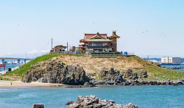
It starts at Kabushima, the island with the shrine on it: the foot of that island is kilometre zero. From there the trail runs south along the water past the Ashigezaki lookout below Samekado lighthouse, Osuka beach, Nakasuka, and the Tanesashi natural lawn, ending at Okuki fishing harbour. The Ministry of the Environment gives the section as 12km.
Allow four to five hours including breaks and photographs. The ministry's own day-trip model course is about 11.3km and roughly four hours, but people stop a lot on this coast, so I tell guests five. Route details and maps are on the ministry's Hachinohe route page.
The distance sounds harder than the walk is. There are rocky shelves to cross and sand to plod through, but nothing you would call a climb. If you can give it the hours, you can finish it without being a walker.
North to south, or south to north
Either direction works, but I suggest starting at Kabushima and walking south, for three reasons.
- The trailhead is the closer end: Same Station is about twenty minutes from Hachinohe, so you do not need an early start
- You get the rockier first half done while your legs are fresh
- It ends at the Tanesashi lawn. Finishing a day's walk sitting on grass looking at the Pacific is a good way to finish a day's walk
Go the other way if you want the lawn to yourself first thing in the morning for photographs. Just note that Okuki, at the southern end, has limited services, so a south-to-north start needs a firmer plan for the train out.
What each stretch is actually like
Kabushima to the Ashigezaki lookout
The first stretch alternates between seafront path and road. Black-tailed gulls are on Kabushima from late February to early August, so in that window you spend the first half hour walking away from the noise of forty thousand birds. The Ashigezaki lookout is a stone structure like an old watchpost on a headland, with the Pacific opening flat in front of it. This is your first real rest stop.
Ashigezaki to Osuka beach and Nakasuka
Past the lookout you come out onto Osuka beach, about 2.3km of white sand. In the right conditions it squeaks underfoot — singing sand, produced by quartz grains rubbing together, and said to be a sign of sand with few impurities. It does not always do it. Treat it as a good omen rather than an itinerary item.
Sand costs more time than its length suggests; budget it at something like one and a half times a paved kilometre and your plan will survive. After the beach comes Nakasuka, the stretch known as the flowering shore, where coastal and alpine plants grow in the same place — the richest part of this coast for wildflowers.
The Tanesashi lawn to Okuki
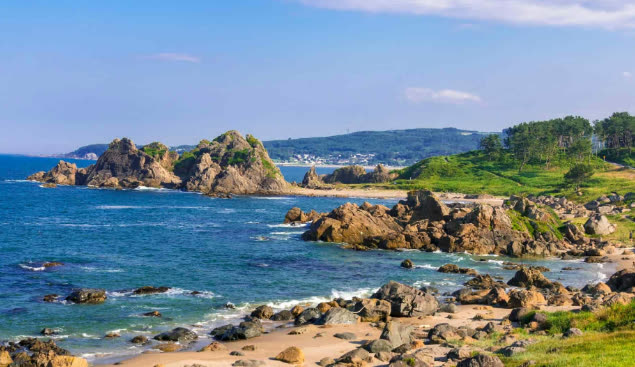
The Tanesashi natural lawn is the one place that explains this coast in a single view: grass to the waterline, then rock, then the Pacific. You can sit straight down on it, which is why most people eat lunch here. Directly in front of the lawn is the Ministry of the Environment's Tanesashi Coast Information Center — free to enter, with toilets. It opens 9:00–17:00 from April to November and 9:00–16:00 from December to March; hours and closures shift around the new year, so check before you go in that season.
From there to Okuki is the final stretch, and the quietest. The visitors thin out and the path runs between a working harbour and the houses behind it. If you still have the legs, walk it — this is the part most people never see.
Past Okuki the trail carries on into Hashikami, the next town south: about 33km, and the only part of the whole 1,000km that climbs a mountain. It is a completely different proposition from this section, so if you are thinking of continuing, read the Hashikami article first.
You can stop whenever: how the escape routes work
The best thing about this section is that quitting is built in. The JR Hachinohe Line runs parallel to the coast, with stations at Same, Mutsu-Shirahama, Tanesashi-Kaigan and Okuki. Whenever you have had enough, walk to the nearest one and ride back to Hachinohe.
The catch is frequency: roughly one train every one to two hours during the day. Arrive at a station on city instincts and you will wait an hour on a bench. Note down two candidate trains home before you set off.
The other option is the Umineko sightseeing bus between Same and Tanesashi-Kaigan stations. It stops at Kabushima, the Ashigezaki lookout, Osuka beach and the Tanesashi lawn — essentially the trail's own highlights — so you can ride back over what you walked, or skip a stretch you would rather not. In the 2026 season it runs daily from 1 April to 8 November, and from 9 November through the winter on weekends and holidays only. There are also days it does not run at all, so check dates and times on the city's official Umineko bus page.
What I actually recommend: take the train to Kabushima, walk as far as you want, and come back by bus or train. People who set out to finish the whole section enjoy it less than people who set out to walk until they feel like stopping. Getting around from the west exit in general is covered on our access page.
The map, and what to bring
One thing catches people out. The Michinoku Coastal Trail is signposted on the assumption that you are carrying a paper trail map, and some stretches are still thinly marked. The Hachinohe section is one of the harder ones to get lost on, being coastline, but where the route turns inland through a village you will want to confirm where you are.
The ministry stopped handing out free paper maps in March 2021; the map book is now published by the NPO Michinoku Trail Club. Check how to get hold of the current edition on the ministry's official trail site. For a single day on the Hachinohe section, printing the course map from that site or saving it to your phone is enough.
- Shoes you have walked in — there is sand and there is rock. Not sandals
- A windproof layer — the wind comes straight off the Pacific, and it matters even in August
- Water and food — there is almost nothing to buy along the route. Stock up near Hachinohe or Same station
- Sun protection — the lawn and the beach have no shade at all
- A power bank — essential if the map lives on your phone
Toilets are at Kabushima Kaihin Park, Kabushima Shrine and the Tanesashi information centre. They are further apart in the second half, so use the information centre before you carry on.
Choosing a season
- Spring (March–May) — the gulls are back on Kabushima. The wind is still cold; bring a jacket
- Early summer (June–July) — the most flowers, but strong sun and very little shade
- Summer (August) — the green of the lawn and the blue of the sea at their sharpest. Carry more water than you think
- Autumn (September–November) — the best walking of the year: fewer people, settled temperatures, wind not yet fierce. The Umineko bus still runs daily until 8 November
- Winter (December–February) — hard wind and a much lower felt temperature. The Umineko bus is weekends and holidays only. Walk a short section and fix your train times first
If a guest has one free day in September or October, this is what I tell them to do with it, ahead of anything else. Tanesashi after the summer crowds leave is genuinely quiet.
A day from Nvillage
- Morning — leave the house, ten to twelve minutes on foot from Hachinohe Station West Exit, and pick up lunch and water on the way to the train
- Get off at Same (about twenty minutes) and walk fifteen minutes to Kabushima, where the trail starts
- Late morning — on to the Ashigezaki lookout, first proper break
- Midday — Osuka beach, then the Tanesashi lawn. Lunch on the grass and a stop at the information centre
- Afternoon — on to Okuki if your legs are willing; otherwise train from Tanesashi-Kaigan or the Umineko bus back to Same
- Evening — back at Hachinohe Station and into the yokocho. Senbei-jiru lands very well after twelve kilometres
If you are carrying lunch, buy it the day before at the Hasshoku Center. The markets and bar alleys are covered in our area guide, and visits to the people who make things here are on the experiences page.
Where to stay for this
Base yourself near Hachinohe Station: the Hachinohe Line starts there and so does the shinkansen. Nvillage is a ten to twelve minute walk from the west exit, with smart-lock self check-in, so not knowing what time you will finish walking is not a problem.
What matters on the evening of a twelve-kilometre day is unglamorous: getting the sand and sweat out of your clothes the same night in the washer and dryer, and putting your legs back together in the barrel sauna (paid, reservation required). Some guests stay several nights and split the walk across two of them. Ask us about rooms and dates through the contact page — nothing needs to be fixed yet.